First a history and geography lesson - Description of Victoria Falls from Wikipedia:
The Victoria Falls or Mosi-oa-Tunya are one of the world's most spectacular waterfalls. The falls are situated on the Zambezi River, on the border between Zambia and Zimbabwe, and are roughly 1.7 km (1 mile) wide and 128 m (420 ft) high. They are considered a remarkable spectacle because of the peculiar narrow slot-like chasm into which the water falls, so one can view the falls face-on.
David Livingstone, the Scottish explorer, visited the falls in 1855 and renamed them after Queen Victoria, though they were known locally as Mosi-oa-Tunya, the "smoke that thunders". The falls are part of two national parks, Mosi-oa-Tunya National Park in Zambia and Victoria Falls National Park in Zimbabwe, and are one of Southern Africa's major tourist attractions. They are also a UNESCO World Heritage Site.
Vastly larger than North America's Niagara Falls, Victoria is only rivalled by South America's Iguazu Falls (excluding large rapid like falls such as Livingston de Chutes). Iguazu and Victoria are generally regarded as the world's most spectacular waterfalls, with people divided as to which is the more impressive. Whilst Iguazu is divided into over 270 (relatively) 'small' falls and cataracts, Victoria is the largest single sheet of water in the world , over 100 meters tall in parts, and over one mile wide.
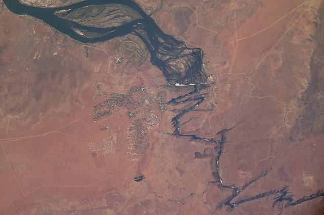

NASA Satellite image showing the broad Zambezi River falling into the narrow cleft and subsequent series of zigzagging gorges. Jordan did NOT take this picture. Click on the picture to see a larger image.
If you go to the following link you see an even more amazing sateliite image of Victoria Falls. Click on "View the Full Size Image". Our hotel is in the picture just above the falls and the swimming pool is visible. Space Imaging

No comments:
Post a Comment